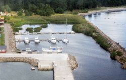
Ruhnu (Ringsu) Marina 

 |
| Ringsu Port | ||
| The centre coordinate of the port | ||
| latitude | 57°46,8´N | |
| longitude | 23°16,3´E | |
| Water area | 2.56 ha | |
| Land area | 4.1 ha | |
Ruhnu (Ringsu) Marina is located on the Ruhnu Island ̓ s south-eastern top on the Ringsudden cape. Ruhnu port building has visitor’s toilets, showers and a sauna. Vessels can be registered into the port in the same building. The other services offered by the port include supplying vessels with electricity and technical water and waste collection on the quay. The port can receive vessels whose lengths does not exceed 20 m and draught 2.5 m. There are 20 quay places in total. The radio call sign is ULL channel 16, "Ruhnu Harbour".
The port is formed by a western direction protected with boulders 540 m long western breakwater, a 140 m long extending from it southern breakwater ending south-east directional iron/beton pier extension. In the port water area there is 36 m long S-SE directional iron/beton quay with iron/beton shore ramp. The dredged channel of the port has a total length of 1130 m, the declared depth of the channel is 3.0 m and the narrowest width is 50 m.
Ringsu Port is a structural unit of Saarte Liinid Ltd.
History
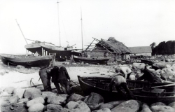
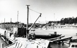
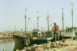
Ruhnu lacked a place where boats could land. According to the winds they stopped in that side of the island where they could find shelter against wind. The only wooden quay was at Limo, but there too the bigger boats and steamers had to stand at anchors further away from the coast. The passengers and cargo were brought to shore in rowing boats. Ringsu cape probably had already the landing place in 1949 when the collective fishery “Ruhnu” was formed. The biggest step in the life of Ruhnu Island was the building of the harbour. The construction of Ringsu harbour began in the 1960s. Junipers were placed between the jetty to make it stronger and hold sand and mud together. The rocks for the jetty were gathered from the fields and also from the stone fences of the village. For the pier, castes of logs were placed on the ice in winter setting in their right places as the ice melted. The castes were later filled with rocks and joined by planks. During the days of the collective fishery, a railroad was built between the harbour and the fish salting department to ease the transportation. The railroad was also used for the reconstruction works in the harbour, for instance when bringing rocks for the jetty. On 15 April 1961, before the quay was ready, Ruhnu had to survive one big storm. Almost immediately after the harbour was finished in 1969 they had to survive another great storm. The damage was so big that the harbour is not even today fully reconstructed. The harbour had a place for receiving fish and a cold storage space. Since 2000 the administration of Ringsu Harbour was assigned to AS Saarte Liinid. In 2001 a small house with toilets, showers, and sauna for the visitors was built in the harbour. In the same building you can register small boats into the harbour. The great storm of 2005 destroyed the port buildings. In 2005–07 a new quay was built, the building of the port and the western piers were reconstructed, navigation system was upgraded and a marina was built.
|  |  |
External links
- Ringsu Port on the webpage of the SL Marinas.ee
- Ruhnu sadamakohvik (in Estonian)
Created in 2013
 |