A settlement with the ruins of a lighthouse at Pärsi 

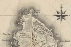
The lighthouse is situated on Pärsi cape. Livonian Atlas completed by Ludwig August Mellin in 1798.
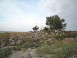
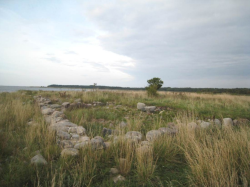
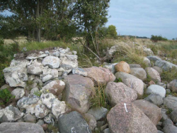
A settlement with the ruins of a lighthouse at Pärsi, an archaeological monument on the western shore of Ruhnu island (under state protection since 2008). More than 50 m from the seawater line, ruins of three different buildings revealed themselves during the January storm of 2005 at the height of approximately 1.5 m on the pedestal of the coastal wall. It could be the basis of the buildings of the lighthouse complex that belonged to the Swedish admiralty.
With the Swedish admiralty´s decision, a swinging-type beacon was constructed on the west coast of Ruhnu island to the cape of Pärsi in 1646. Similar beacons were at the time also established to the Sõrve Peninsula and Domsnäsi aka cape of Kolka in order to simplify marine traffic in the Gulf of Liivi and increase trade with Riga, Pärnu and Kuressaare. The Swedes had planned to build there a fortress but based on the known sources, the fortress was never built. In early 1760s, Pärsi had already a two-storey four-sided wooden tower, which had a burning light on its open platform. The Ruhnu lighthouse (Feuerbake) is situated on the cape of Pärsi also on the map of the Ludwig August Mellin´s „Atlas of Livonia“ (1798), whereas the coastal guard´s (Strand Reuter) building can be seen nearby. In 1810, a new 24 m high eight-sided wooden lighthouse was built at Pärsi. The lighthouse received a lantern room and a catoptric light system with oil lamps and silver-plated copper reflectors. In 1856 a new location for the lighthouse was chosen on the eastern coast of the island.
According to the marine historian Burno Pao, the ruins of the building of the southernmost and the highest hill from limestone quarry with a diameter of almost 9 m are probably the basis of the more than 200-year-old lighthouse or a round cellar. Coal and pieces of lumpy cinder were found nearby. The lime mortar laid foundation from granite stones of the longer building could be seen from the edge of the coastal wall 26 m northeast of the ruins directly on the beach. The building consisted of three rooms with partition, each of which had its own brick oven. They are most likely the barracks of the coastal guard or even a beach house similar to a chapel. The third basis, situated in the mouth of a small bay, where ruins of a limestone oven and the base of the mantle chimney revealed themselves, is the oldest. It was probably already in use in the 18th century as the house of the coastal guard looking after the whole Ruhnu coastline, which is also marked on the Mellin´s map.
 |  |  |
Related articles
References
- Ruhnu Chronicle II. 2010
- J. Vali. Eesti tuletornide ajalugu. History of Estonian Lighthouses. Tallinn, 2011
Created in 2013
 |