Ruhnu vegetation 

When it comes to vegetation, Ruhnu can be divided into two – the higher forested area on the east side and lower area on the west side covered in meadows and grasslands with groves here and there and a vast wetland in the south-western part. On the higher part of Ruhnu (Higher-Ruhnu) it is possible to distinguish between the boreal heath forests, dry boreal forests, fresh boreal forests, fresh boreo-nemoral forests, water swamp forest, minerotrophic swamp forests and poor paludified forests.
Since dunes run in parallel positions, water gathers between them and in poor fens, marshes and small forest areas that are in the process of turning into bogs can be found in some places. The grasslands in the lower part (Lower-Ruhnu) can be divided into dry and wet palurohumaadeks, wet pärisarurohumaadeks, paludified grasslands, fen grasslands, coastal grasslands and agricultural grasslands.
Limo beach on the east coast of the island with its white attaching dunes represents sandy plains type group of the rock and sandy plains vegetation. A. Kalda (1989) has profiled the vegetation in the southern part of the island in the following way (moving 2 km from east to west): white dunes (with groups of wild rye), attaching dunes, dune forest, dry boreal forest, boreal heath forest, paludifying boreal heath forest, swamp forest alternating with smaal areas of fresh boreal forest, paludified meadow with a narrow range of species, large assembles of meadowsweet and canebrake.
In the course key biotype inventory (1999–2002) 23 key biotypes were identified on Ruhnu (mostly in the forests of Higher-Ruhnu). In order to conserve various habitats and biocoenosis Ruhnu Conservation Area was formed in 2007 (includes more than 67% of the territory of the island) – this guarantees the protection of key biotypes within the conservation area.
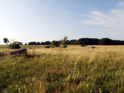 West side of the island is covered in meadows and grasslands | 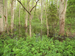 Haubjerre in Higher-Ruhnu | 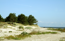 Limo beach on the east coast of the island |
Created in 2014
 |