Ruhnu on the old maps 

One of the oldest map’s which includes Ruhnu island (Runa) is „Carta Marina” of Olaus Magnus (1535). Several maps originate from the end of the 16th century, the atlas „Spieghel der zeevaerdt” by the Netherlands’ cartographer Lucas Janszoon Waghenaer published in 1584–85, is interesting. It includes a page with the map of the Gulf of Riga, where Ruhnu (Runen) is also marked. The oldest map of Ruhnu is the sketch of Olof Holgersson from 1627. Petter Beckman prepared the oldest detailed map of Ruhnu in 1688. There is a church and farms in the middle of the island, in the southeast of the island there is a chapel (Capell el Kärskyrcka) and on the west shore there is a lighthouse. The farms in village in the middle of the island are marked with numbers and the property distribution of land parcels is also represented. The islets around the island, lowlands and higher places on the island have been marked with images of hills. The map of Ruhnu on page 11 of the Ludwig von Mellin’s „Atlas of Livonia” composed in 1798 is also rich in details. In addition to the village and the lighthouse on Pärsi cape, it also shows the chapel (Kärs Kapel) in the southeast part of the island near Ringsu cape and fishermen’s boatsheds in three places (on Kuunsi cape, Överkirke beach and Ringsu cape). Two lowlands next to Ruhnu can be seen on page 6 of the same atlas: Gretagrund in the south and Sandgrund in the east. On the map of 1844, Ruhnu island is mapped in the Gulf of Riga, a detailed plan of the Ruhnu’s parsonage has also been presented. The same collection includes the exceptionally detailed drafts of the Ruhnu’s new church that were not used. A village in the middle of the island, beacon on Pärsi cape and the cordon on the west coast of the island is presented on the map of the European part of Russia since 1855–59. A lighthouse on the top of Kuunsi is also marked on the German version of the same map (compiled on 1866). The map „Livländisches Gouvernement Arensburgscher Kreis. Insel Runo” from 1871 gives among other things a lot of information about tenure and traditional farming. The maps can be found from the Register of Maps in the National Archives of Estonia.
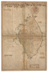 Ruhnu map from 1688 | 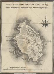 Ruhnu map from 1798 | 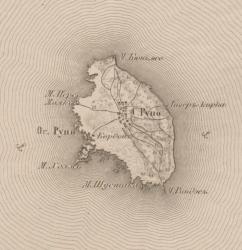 Ruhnu map from 1855 |
External links
Created in 2013
 |